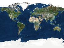
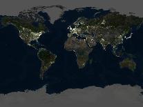
Whole Earth map based on satellite data. Both land and ocean floor topography are shown. The terrain on land is mostly vegetation (green) or arid land (brown). The polar regions are covered by snow and ice (white), though sea ice is not shown. Ocean floor colour varies from dark blue (deep ocean) to lighter blue (continental shelves) and light blue (shallow coastal waters). Major geographical areas include the deserts of North Africa (centre), the mountain ranges in central Asia (centre right), the Amazon rainforest in South America (lower left), the Greenland ice cap (upper left), and the ocean ridges and trenches. This is a cylindrical projection. For this map at night, see E074060.