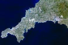
Cornwall, southwest England. Truecolour satellite image of the county of Cornwall in southwest England, Great Britain. North is at top. Cornwall contains Lands End (at lower left) and Lizard Point (at bottom left) which are respectively the westernmost and southernmost parts of the English mainland. Cornwall is largely rural and has a patchwork of fields, but at upper centre is Bodmin Moor (dark green). The city of Plymouth, on the western edge of the neighbouring county of Devon, is at right. At upper left is the Celtic Sea, whilst at lower right the English Channel. Image taken by the Landsat5 satellite.