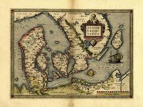
Orteliuss map of Ireland, from an atlas of 1598. North is at right. This map is titled: Hiberniae, Britannicae Insulae Nova Descriptio (A new depiction of Ireland, a British Isle). It is based on Mercators 1564 map. The map text is in Latin and mentions Queen Elizabeth I of England, who was also Queen of Ireland. Quotes are also given from the scholar Gyraldus Cambrensis (Gerald of Wales), concerning the isles of Arran, Saint Patricks Purgatory, and Lacus Erno (Lough Erne). A scale is at lower left. Abraham Ortelius (15271598) was a Flemish mapmaker who is considered to have produced the first true atlas (collection of uniform maps in one book).