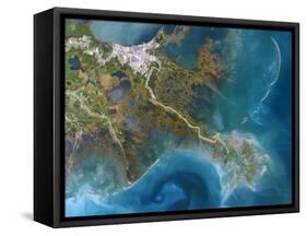
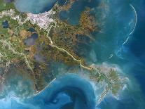
Mississippi Delta, USA, satellite image. North is at top. The Mississippi River flows from top left through the city of New Orleans (white, upper left), and down to lower right, and out into the Gulf of Mexico. Much of the land in the image has been built up by sediments deposited by the river. The latest phase of delta formation can be seen at bottom right, and swirling patterns in the water and varying colours show the formation of sand banks and the presence of turbulent sediments. This area is around 200 kilometres across. Image data obtained on 12 October 1991.