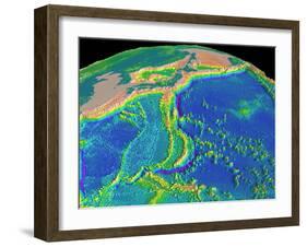
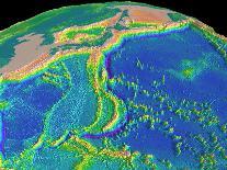
Mariana trench topography. Computer model of the topography of the region surrounding the Mariana trench (purple arc, lower centre) in the Pacific Ocean, the deepest point on Earth. The model was made by combining data from ship soundings and satellite altimetry. Depth is colourcoded, from redpink (highest) through yellow, green and blue to purple (lowest). Land is dark green. The islands of Japan are seen at upper centre, with the Korean peninsula to their left. Numerous seamounts, which are of volcanic origin, are seen in the Pacific Ocean at lower right.