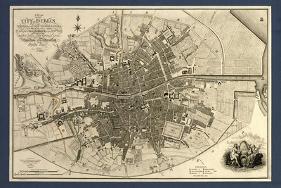
Map of the City of Dublin, Ireland. Published in 1797, this map includes details of the canals being built at the time. Canal Harbour (lower right) connects across bottom with the Grand Canal (lower left). The Royal Canal (upper right and a branch at upper centre) was a competing canal. Running across centre is the River Liffey. Borders of the citys wards are marked in coloured lines, with a key at lower right, next to the city coat of arms. The scale at lower left is in both English and Irish miles. In 1797, Ireland was ruled by Britain, and this map was published by the geographer to King George III and the Prince of Wales (the future King George IV).
Transportation Art
Partake in a sailing regatta or feel the wind in your hair cruising in a ‘Vette. Go places without leaving home. Give wings to self-expression with our transportation art collection.
Pick the perfect ride for your walls from mega jets, cool kayaks to vintage race cars. Get them wall-ready and fabulous in our handcrafted frames, starting at $59. Famous works of art from this collection include Monet’s Sailboat, Sleep Balloon by Nancy Tillman. Vapor Helicopter by Banksy.
Work by Library of Congress
View All
Related Categories
- Top
- Travel
- World Cultures
- Landscapes
- Natural Landscapes
- Architecture
- History
- Transportation
- Rivers
- Italy
- Architectural Elements
- Ireland
- Science
- Venice
- United Kingdom
- England
- Europe
- Coat of Arms
- Italy's Canals
- Urban Landscapes
- Street Scenes
- Industrial Architecture
- C
- Artists
- Art
- Subjects
- World Regions
- Geography
- Browse The United Kingdom
- European Nations
- Browse Italy
- Italian Landscapes
- Maps
- Maps of Europe
- Maps of the World
- Dublin
- Grand Canal
- Artists by Name
- Humanities
- Social Sciences
- Canals
- European Cultures
- Other Subjects
- British Culture
- Docks
- Coastal Architecture
- Coastal Architecture by Subject
- Maps of Ireland
- Congress, Library of
- Venice Canal Scenes
- Maps of Dublin
- Beach & Nautical
- Landscapes by Type
- Streets & Roadways
- Key European Cities
- Landmarks of the World
- European Landmarks
- Back to School