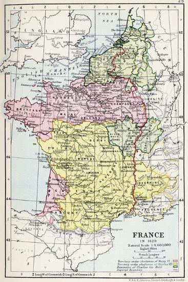
Map of France in 1429, from 'Historical Atlas', Published by W. and A.K. Johnston Limited, 1911
Choose size
Finished Size: 12" x 18"

Just the Print
$32

Chelsea Black
$137

Chelsea White
$137

Chelsea Espresso
$137

Stretched Canvas
$79

Canvas Black
$151

Wood Mount
$101

Laminate
$57

Just the Print
$38

Chelsea Black
$154

Chelsea White
$154

Chelsea Espresso
$154

Stretched Canvas
$89

Canvas Black
$161

Wood Mount
$128

Laminate
$63

Just the Print
$49

Gramercy Black
$286

Gramercy White
$286

Gramercy Espresso
$286

Stretched Canvas
$169

Canvas Black
$241

Wood Mount
$151

Laminate
$74

Just the Print
$87

Gramercy Black
$544

Gramercy White
$544

Gramercy Espresso
$544

Stretched Canvas
$339
Framed Canvas
Wood Mount
Laminate
see more frame options
$32
Arrives by Fri, May 9 to 66952

$32
12" x 18" - Giclee Print
12" x 18" - Giclee Print