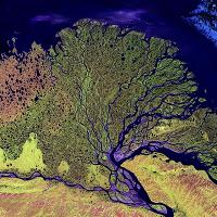
Lena River Delta, Russia, satellite image. This is the mouth of the Lena River in the Arctic, where water (dark blue, flowing bottom to top) branches into many channels as the river meets the sea. The sediment washed downstream by the river forms new land (green). Higher land (along bottom, red and yellow) channels the rivers course. The Lena is 4400 kilometres long and drains a large region of Siberia, flowing into the Laptev Sea of the Arctic Ocean. The delta supports much marsh wildlife. The image is over 150 kilometres wide. Image acquired in visible and infrared wavelengths on 27 February 2000 by the Enhanced Thematic Mapper Plus (ETM+) sensor on NASAs Landsat 7 satellite.