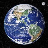
Earth from space. Satellite image showing North and South America as seen from 35,000 kilometres above the Earths surface. North is at top and the Moon is at upper right. Clouds (white) are seen, as are seas and oceans (blue). Land cover ranges from vegetation such as forests and grassy plains (green) to arid areas such as deserts, mountains, and scrublands (brown). This image combines data from the Moderate Resolution Imaging Spectroradiometer (MODIS) instrument aboard NASAs Terra satellite and NOAAs Geostationary Operational Environmental Satellite (GOES).