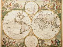
The known World in the late 17th Century. Map of the world taken from the World Atlas of Frederick de Wit, dated 1689. The map is shown as a Fournier projection, the most common of the day, with seperate polar plots. The map shows the extent of contemporary exploration, and some of its errors (California is shown as an island, for example). The map is surrounded by allegorical scenes depicting the rewards of exploration and its pitfalls (reclining man being violently sick near bottom left). There are also references to zodiacal persons and creatures.