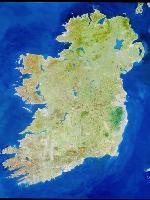
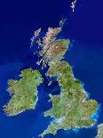
Ireland. Truecolour satellite image of Ireland. North is at top. The islands main cities are Dublin (centre right) and Belfast (upper right). Ireland is often called the Emerald Isle because of the vivid greenness of its countryside; this is largely due to the warm, wet winds from the Atlan tic Ocean to the West. Topographically, the island is shaped like a basin, having lowlands in its centre & hilly ranges around its coastline. Ireland has many lakes, including the largest in the British Isles, Lough Neagh (at upper right). The longest river in the British Isles, the Shannon, empties into a long, narrow estuary at lower left. Image taken by the Landsat5 satellite.