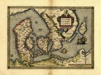
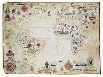
18th century map of the world. Published in Paris in 1720, this French map shows the known world, including the new lands that had been discovered in the preceding centuries by Europeans exploring across the Atlantic and far to the East around Africa. It divides the Earth into a western and eastern hemisphere, and uses colour to mark different areas of land. The map is by Guillaume de lIsle (16751726), the leading French cartographer of the eighteenth century. He was appointed Premier Geographe du Roi to King Louis XV in 1718. This edition of his world map includes the western and northern coastlines of Australia, mapped by the Dutch. Australias eastern coastline would not be mapped until 1770.

Work by Library of Congress
View All
Related Categories
- Top
- Travel
- Asia
- World Cultures
- History
- Science
- World Maps
- C
- Artists
- Art
- Subjects
- World Regions
- Geography
- Maps
- Spanish Culture
- Maps of the World
- Artists by Name
- Humanities
- Social Sciences
- Asian Cultures
- European Cultures
- Other Subjects
- North American Cultures
- South American Cultures
- Middle Ages
- Congress, Library of
- Back to School