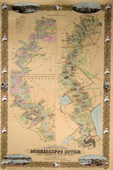
Map Depicting Plantations on the Mississippi River from Natchez to New Orleans, 1858 Giclee Wall Art
Choose size
Finished Size: 12" x 18"

Just the Print
$25.60
$32

Chelsea Black
$84.70
$121

Chelsea White
$84.70
$121

Chelsea Espresso
$84.70
$121

Stretched Canvas
$51.75
$69

Canvas Black
$90.30
$129

Wood Mount
$63.70
$91

Laminate
$42.75
$57

Just the Print
$30.40
$38

Chelsea Black
$107.80
$154

Chelsea White
$107.80
$154

Chelsea Espresso
$107.80
$154

Stretched Canvas
$62.30
$89

Canvas Black
$104.30
$149

Wood Mount
$89.60
$128

Laminate
$47.25
$63

Just the Print
$39.20
$49

Gramercy Black
$200.20
$286

Gramercy White
$200.20
$286

Gramercy Espresso
$200.20
$286

Stretched Canvas
$111.30
$159

Canvas Black
$153.30
$219

Wood Mount
$105.70
$151

Laminate
$55.50
$74
see more frame options
$25.60
$32
Get it by Christmas
Arrives by Fri, Dec 12 to 66952

$25.60
$32
12" x 18" - Giclee Print
12" x 18" - Giclee Print