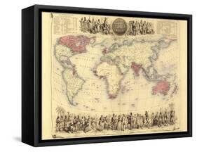
British Empire world map. This world map shows the 19thcentury British Empire (pink) and its indigenous peoples. Five illustrations (clockwise from upper left) show the people of Australia, North America, southern Africa, Europe and Asia. Two tables (top left and top right) list the imperial possessions by area and population, with the totals being over 7 million square miles and nearly 165 million people. Some years of acquisition are also shown. This map was produced in the late 1850s by the Scottish cartographer John Bartholomew (18311893). Africa includes the 1856 route taken by the Scottish explorer David Livingstone.